")
")
The efficiency of decision making in any sector of the economy depends on the completeness of the initial data, their quality and the tool used to analyze and prepare an action strategy. Over the entire long history of the oil and gas industry, a colossal amount of unsystematic information has been accumulated.
The Geoleader company offers the optimal solution for creating an information environment and data management - the PetroVision software package. The formation of the Data Bank is carried out on the basis of multilevel quality control, which guarantees relevance, consistency and correctness of the material. It provides fast and convenient access to data based on GIS technologies, by index and contextual search. Tools for analyzing and visualizing materials specific to the oil and gas industry are provided. Creating a structured storage system improves not only the speed of decision-making, but also the efficiency of managing the E&P process.
The PetroVision software package is an integrated environment for managing geological, geophysical and field information, positioned as the PetroVision Databank.
The main idea of PetroVision is to provide maximum ease of loading, quality assessment and work with a full set of exploration and production (E&P) data, namely, viewing, searching, accessing, visualizing, querying and delivering data. PetroVision is based on Oracle Database, GIS Interface and ESRI ArcGIS Server technologies.
PetroVision provides access to data stored in the Oracle database, as well as external files located in disk or robotic storage, and a wide range of tools for manipulating these data.
The history of the creation of the PetroVision Data bank begins in the 80s-90s of the previous century, when the CGG company introduced this product to the world market. Since 1997 PetroVision has appeared in Russia. In 2006, the product was purchased from CGG, and now it is the property of Geoleader LLC and continues to develop to this day.
The capabilities of PetroVision allow you to load high-quality data (desktop applications WellQC and SeismicLoader are responsible for the quality, and the CLUEToolLoader universal loader is responsible for loading), sort, select according to the established rules and view the contents of files of various formats of geological, geophysical and field information, as well as documents with a standardized structure. Viewing and visualization is implemented with the help of auxiliary applications:
- Seg-y Viewer - for viewing and visualizing seismic data;
- Log Viewer - for viewing the data of geophysical exploration in wells (formats: las, lis, dlis, witsml, zak);
- Image Viewer - viewing images, graphic formats, office suite files, etc.;
- Arche Viewer - viewing archived files.
Learn more about viewing applications - PetroVision. Viewing files.
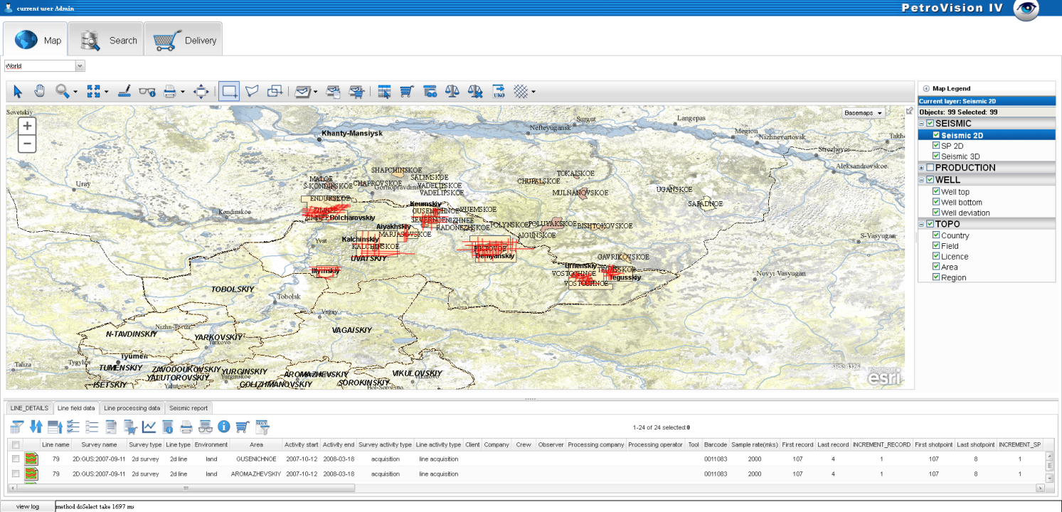
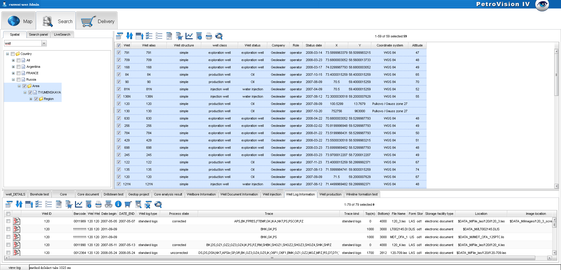
The Map and Search modules are a single center of access to all information stored in the PetroVision Data bank. You can very quickly find an object of interest, as well as submit a query to the database, view the files selected by the query results, create and send a report by e-mail.
The Delivery module allows the user to collect any files in a basket, create the basis of a design base with selected data, or send files to the input of other programs, interpretation complexes, processing or archiving systems on magnetic tapes. You can send files by e-mail or over the network to another computer. It is possible to send an e-mail request to the operator to print the files in the basket, or write them to a CD and other media.
The main component of the Data Bank exists in two versions:
-
PetroVision IV web version that allows you to work with any modern web browser
-
Desktop version of PetroVision V running under Windows and Linux operating systems
The advantages of PetroVision software are determined by the original configuration architecture, which allows it to be successfully applied to any databases, including those based on POSC Epicenter and PPDM data models. PetroVision is a unique development in the field of information storage and management, covering the entire possible spectrum of geological, geophysical and field data. The PetroVision Databank is registered with the RosReestr of domestic software and can be used within the framework of the import substitution program.
Development prospects are driven by the ongoing daily work to improve the PetroVision system. The following functionality is planned for the near future:
-
Different types of charts and graphs for data analysis and visualization;
-
Improved mechanism for selection by specified criteria,
-
Development of a Web application for 3D visualization of wellbores and digital models,
-
Development of a web version of data loading and many other tasks.